User Experience in the Landscape: a San Antonio Park
This project‘s goal is to create new corridors that interweave social and ecologic systems by restoring the historic creeks that were straightened and channelized in San Antonio between 1957 and 1998. These creeks were altered in order to prevent water flooding from storms.
San Antonio has invested time and money in its north to south natural and recreational corridor along the San Antonio River. This connection focuses on tourism and downtown redevelopment, with a new museum and mission reach of the famous Riverwalk. While those developments unfold, this project advocates to create a West to East corridor along the city’s west side creeks, where local communities of predominantly Hispanic & Latino residents are prone to severe flooding during heavy rainfall and are undeserved of basic social and ecological amenities.
Though channelized for flood prevention, the creeks no longer serve this purpose and have decimated the pre-existing ecologic systems of the area, and the expansion of the city itself has grown to become urbanized. This project focuses on a 1.3 mile stretch of Zarzamora Creek, which I identified as a potential area to create social, ecologic, and flood prevention systems. In addition, the project utilizes a Deployable Strategy for the West Side Creeks. The strategy was designed to become a prototypical solution that is replicable in the rest of the creek system of west San Antonio, allowing for a new form of connectivity and amenity to emerge.
The creeks are a mythical place that represents danger. The communities of San Antonio seldom think about the creeks or use these spaces; There is no desire to do so. Ironically, the city has a rich history with water resources and human interaction and intervention of the local water systems. San Antoni[ooz] aims to challenge the notion that its creeks are inaccessible and dangerous by conceiving new ways that the community can interact with ecology, recreation, and the very essence of the city of San Antonio, which are its water resources.


From West to East
San Antonio’s North to South connection is established. The focus of this project is creating a West to East corridor that addresses ecologic and social amenities and introduces flood-preventive measures

Zarzamora Creek, West San Santonio, TX
Focusing on a 1.3 mile stretch along this creek, the site lies about 5 miles west of Downtown San Antonio.

West Side Water Creek System
San Antonio has a long history in regards to water resources. The city is adamant about water conservation efforts and flood prevention. These, however, focus broadly on downtown, leaving western communities undeserved.

The Water Creeks through History.
Beginning in the 1940’s and up until the early 1990’s , San Antonio straightened and concretized the natural creek system in order to prevent floods from storms.

The Water Creeks Today
In their current form, these spaces are desolate and in essence became a no-man’s land. They are separated from their communities both physically and psychologically.

Water Flooding
Downtown San Antonio no longer floods. The west side however, does often. From 2000 through 2013, over 175 flood events were recorded in the city. That means that the city of San Antonio saw an average of 13 floods per year.

Where People Live vs. Where Parks Are
West San Antonio, where the majority of these floods happen, is predominantly Hispanic/Latino. This maps shows the population distribution, the dots represent 25 people. The orange dots represent Hispanic populations. This map also highlights the correlation between public open green space & population distribution.

Native Ecology
Historically, west San Antonio was dominated by the Blackland Prairie ecoregion. It is an ecologic system that supported clumps of woodlands and tall grasslands and meadows with abundant streams.

Impervious Surface
With San Antonio’s growth, the urbanization of the ecoregion accelerated. This disturbed the natural systems and created many of the flood hazards we see today. This urbanization also spurred the channelization of the creeks.

Green Cover
In turn, the balance between impervious development, which doesn’t allow water to naturally recharge the water table, and vegetative coverage is not equal, leading to floods during rain events

From East to West
The larger strategy, proposes to naturalize these water channels along undeveloped or underdeveloped parcels along these, therefore creating a resilient open space that can help mitigate flood risk.

A Natural Link
The naturalized creeks would be enhanced by public access with opportunities for programmatic space. This would help create a link through an element that continuously traverses the urban fabric of San Antonio

Identifying Program Needs
Once connected, the proposal looks at the needs of these communities in terms of program. A study of Parks, Playgrounds, Community Centers, and Educational centers in relation to the creeks, allows us to propose additional areas that can be placed along the natural creeks.

Design Strategy
At a smaller scale, the design strategy sets up conditions for Program, Vegetation and Water. Closer to the community edge, the space is open, active and safe from floods. As you near the creek, the space becomes intimate and exploratory, while allowing for water to naturally flood during storm events.

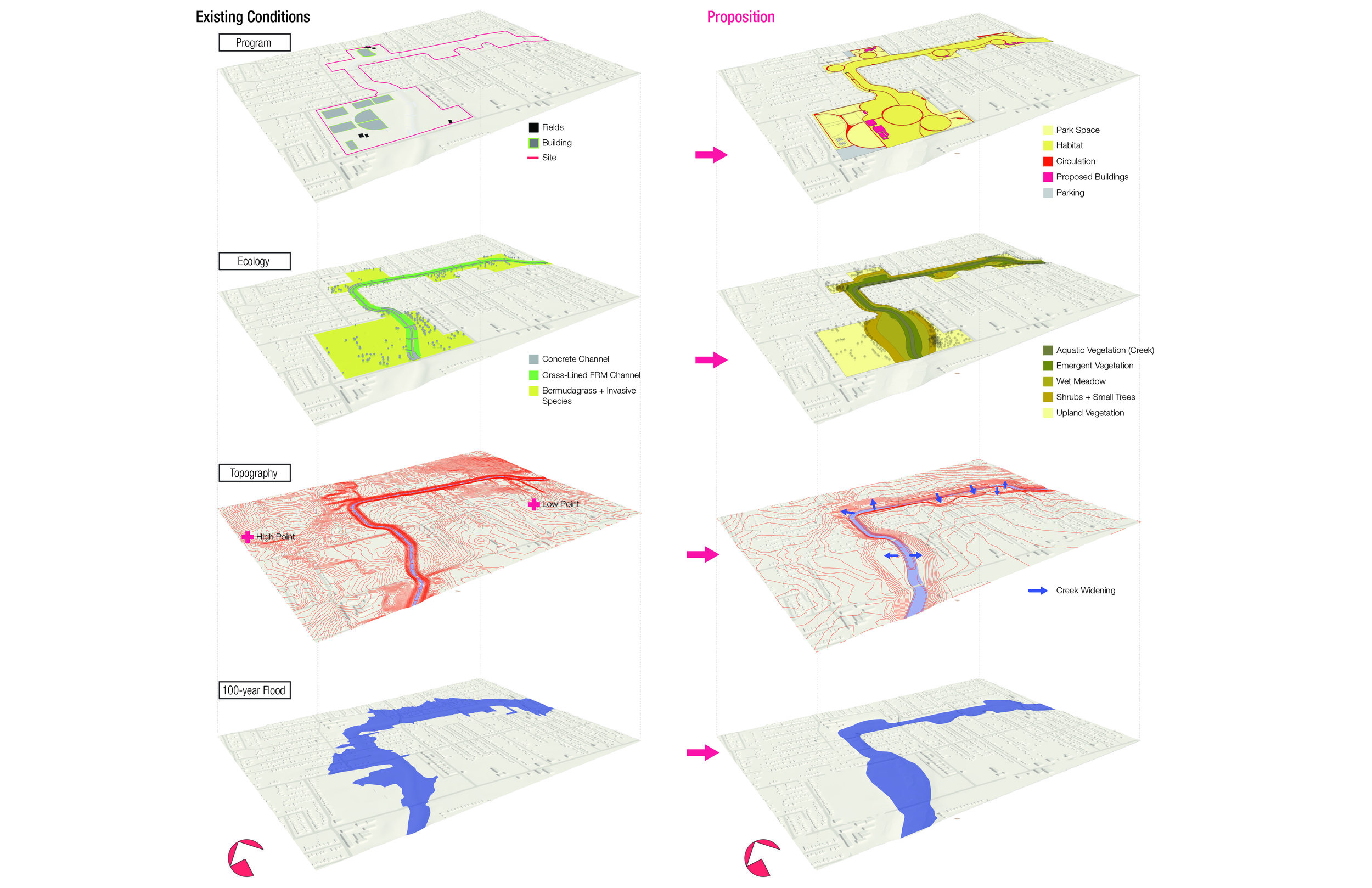
The Project Site: Existing & Proposed Conditions
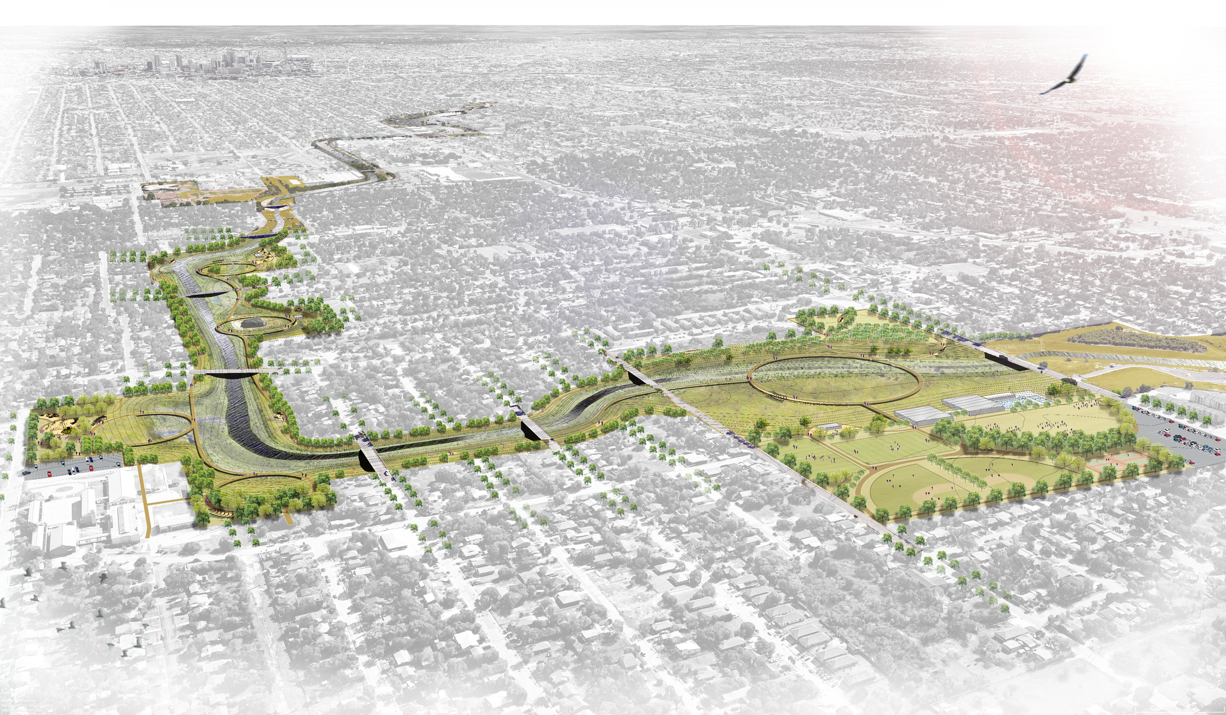
The design strategy is then deployed into the chosen site. Existing conditions of the area are harsh with damaged sports fields, concrete water channels, limited vegetative cover, and frequent floods. The proposal adds public access through a trail system, adds community spaces, playgrounds & parks, and enhances the vegetation. The community can access these trails and be immersed into the ecology here.

Site Design: Visualizing the idea.
Once refined, I set out to visualize what the design strategy as a physical manifestation. I created various illustrations depicting the existing conditions of a portion of the park, and showed how the park functions in a normal state and during a storm.


